Presentation

AlpineQuest is the complete solution for all outdoor activities and sports, including hiking, running, trailing, hunting, sailing, geocaching, off-road navigation and much more.
You can access and store locally a large range of on-line topographic maps, which will remain available even while being out of cell coverage. AlpineQuest also supports on-board file based maps, like MemoryMap© maps.
By using the GPS and the magnetic sensor of your device (with compass display), getting lost is part of the past: you are localized in real-time on the map, which can also be oriented to match where you are looking at.
Save and retrieve placemarks, share them with your friends. Track your path, get advanced statistics and interactive graphics. You won't have anymore questions about what you can accomplish.
By staying fully operational out of cell coverage (as often in mountain or abroad), AlpineQuest assists you in all your desires of deep wilderness exploring…
AlpineQuest is available for all Android powered devices (including mobiles, laptops and tablets). While it has been reported to work correctly on LineageOS and /e/OS, we do not offer technical support on those plateforms. Please note that it is not available on iOS and Windows phones.
Version 2.4.0b is available! (release note)
Maps stay available, always.
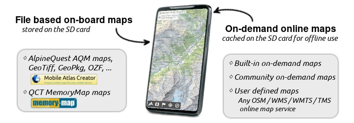
AlpineQuest can use file based maps stored on your SD memory card, available even in non-networked areas.
You can also display maps from online websites when an Internet access is available. All the data is automatically stored locally for offline use.
Maps are fast to display, no more dependence to the network signal quality, downloaded data volume is drastically reduced.

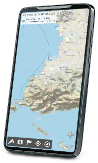
The map can be oriented according to the North (using the magnetic sensor), and you can be located on them (using the GPS chip).
You can create your own file based offline maps using the free Mobile Atlas Creator software. It allows you to create maps on your PC using your high speed home Internet access.
| Features | AlpineQuest Explorer Lite | AlpineQuest Off-Road Explorer |
|---|---|---|
| Display AlpineQuest (.AQM/.PGD) file based maps | | |
| Display and store locally built-in online maps (road, topo and satellite maps available), including USGS Topo and Swiss Topo maps | | |
| Display maps as layers with dynamic opacity, contrast and saturation control | | |
| Offline elevations management (DEM) with high-quality terrain, hillshade and slopes layers | | |
| Display file based on-board maps like GeoPackage, Memory-Map QCT, OziExplorer OZF2, MBTile, GeoTIFF, CompteGPS RMaps, etc. | | |
| Import KML/KMZ raster overlays from calibrated images | | |
| Add more online map sources from the Community Maps list, from MOBAC custom map files or user defined | | |
Placemarks
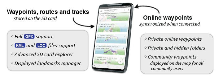
With AlpineQuest you can browse and display data from GPX files (standard format for GPS data exchange), KML/KMZ files (used in Google Earth) and LOC files (used for Geocaching).
AlpineQuest can also save locations, create routes, areas, and record tracks. You can get statistics and export them to any compatible application, like Google Earth.

![]() More information on placemarks in AlpineQuest
More information on placemarks in AlpineQuest
| Features | AlpineQuest Explorer Lite | AlpineQuest Off-Road Explorer |
|---|---|---|
| Store locally and retrieve unlimited waypoints | | |
| Handle complex placemarks such as areas, routes and tracks | | |
| Statistics and graphics on tracks | | |
| Impact time-tagged placemarks by time | | |
| Import and export placemarks from GPX, CSV, Google Earth KML/KMZ, OziExplorer PLT/WPT, GeoJSON and IGC files | | |
| Ability to store and share online locations, exchange information on the map with other users | | |
Track your paths without limits
AlpineQuest comes with a powerful GPS Location Tracker that will record all your tracks for hours. At any time, you can get advanced statistics and display dynamic graphics.
By using your device air pressure sensor, AlpineQuest can also compute and use barometric elevations, much more precise than GPS elevations.
![]()
| Features | AlpineQuest Explorer Lite | AlpineQuest Off-Road Explorer |
|---|---|---|
On map localisation, previous locations track, complete GPS and barometer status board1 | | |
Compass, orientation of the map to match your current direction, target finder2 | | |
Built-in GPS Location1 with auto-calibrated Barometric Altimeter3 Tracker | | |
| Complete statistics and dynamic graphics on your tracks (elevations, speeds, inclines, accuracies, pressures, etc.) | | |
| GPX and KML export of your tracks, for use in external applications, like Google Earth | | |
1. require a GPS compatible device, 2. require a compass compatible device, 3. require a barometer compatible device
Don't wait, try it right now!
| AlpineQuest Explorer Lite | AlpineQuest Off-Road Explorer |
|---|---|
| This Lite version is perfect for discovering the application or for occasional users. It's completely free and not limited in time. | Enjoy all features of one of the most powerful Android off-road topo GPS. |
| Price: Free (Ad free) | Price: €14.99 (one time, all future updates included) |
 |  |
| No access to Google Play? Get the APK install file here | Buy the complete version on our website using PayPal |
Contact and support
![]() Don't forget to visit the AlpineQuest Online Help.
Don't forget to visit the AlpineQuest Online Help.
Feel free to contact us for any question, problem, or for sharing your suggestions:
- On our support forum: www.alpinequest.net/forum/ (no registration or e-mail needed, all questions answered);
- By e-mail:
 ;
; - Korean users can find great tutorials, help and information at the official South Korean AlpineQuest Board founded by Solro. There is a complete up-to-date offline help available here.
Translations
AlpineQuest is currently available in the following languages:
- English (officialy supported);
- French (officialy supported);
- Arabic (thanks to Tahiri AB);
- Bulgarian (thanks to Hristo Dipchikov);
- Chinese (Simplified) (thanks to Matthew Cheng and Zhihong He);
- Chinese (Traditional) (thanks to Zhihong He);
- Croatian (thanks to Stefan Trbojević);
- German (thanks to Lukas Kessler);
- Indonesian (thanks to Rio Achmad);
- Italian (thanks to Silvio T and Ulisse DG);
- Japanese (thanks to Koichi Fujino);
- Korean (thanks to Solro);
- Lithuanian (thanks to Dainius M);
- Persian (thanks to Mahdi Mollaei and Mahmoud Seifi);
- Portuguese (thanks to Dinis Medeiros);
- Romanian (thanks to Florin);
- Russian (thanks to Alexlong, Maksnogin and Dam-69);
- Slovak (thanks to Frantisek P);
- Slovenian (thanks to Domen Kastner here)
- Spanish (partially, thanks to Nicolas L);
- Turkish (thanks to Mehmet);
- Ukrainian (thanks to Aleksandr L).
Don't hesitate to contact us if you are interested in translating few parts of the application in another language.
