Table of Contents
Online Help > Settings > Location formats & grids
Location formats and grids
The application can display and search locations in almost any coordinate system.
For all of them, the associated grid (geodetic or projected) can be displayed on the map, along with grid square notations for UTM, MGRS, OSGB, Irish Grid, TPC Grid and DFCI grid systems.

By default, the coordinates of the screen center location are displayed in an information box located at the top left of the screen. If an secondary location format has been chosen in the application settings, both are displayed. The coordinates and grid of the secondary format are displayed in blue.
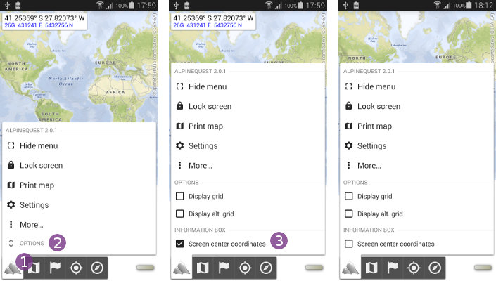
How to display or hide the screen center coordinates?
To display or hide the screen center coordinates information box:
- Tap on the main application menu
 ;
; - Tap on
“Options” ;
; - Check the option
“Screen center coordinates” to display the coordinates, or un-check it to hide them.
How to display or hide the grid?
To display or hide the grid for one of the current location format:
- Tap on the main application menu;
- Tap on
“Options”; - Check the option
“Display grid” to display the grid of the main location format, or un-check it to hide it; - If you've chosen a secondary location format in the application settings, you can display its grid or hide it independently by using the option
“Display alt. grid” . The secondary format grid is displayed in blue.

Here is an example of the UTM Grid over Hawaii:

Here is an example of the MGRS Grid over Hawaii:

How to change the location formats?
To change the location coordinates display format:
- Open the application settings;
- Tap on
“Location format” to change the main location format, or on “Secondary loc. format” to change the secondary location format; - Common worldwide formats are displayed first, local and less common formats are listed by area .
If you cannot find the location format you need:
- Tap on
“Import…” ;
; - Type the EPSG coordinate format ID in the text field
 ;
; - If you don't know it, tap on www.spatialreference.org
 to visit this website that list almost all coordinate formats. You'll be able to make searches by name or country, and retrieve the list of corresponding coordinate format IDs;
 - Tap on
“Ok” to validate;
